BENTONVILLE
GOOGLE MAP - BENTONVILLE/BELLA VISTA

SHORT TRAIL MAPS (about 1 mile)

For detailed maps and descriptions, visit the Road Routes section on Visit Bentonville
For a more relaxed ride, explore these paved trails:
-
Crystal Bridges/Razorback Greenway Trail: A 5.4-mile easy trail starting in downtown Bentonville, leading to Bella Vista Park, and featuring art installations and natural beauty. AllTrails.com
-
Applegate Trail via Applegate Event Space: A 4.9-mile moderate trail along Coler Creek, offering a smooth path with a gradual descent. AllTrails.com
-
North Walton Trail: A 5.3-mile easy trail from the Bentonville Bike and Bark Park south to Walmart, with some road crossings. AllTrails.com
For more options, check out the AllTrails list of road biking trails in Bentonville.
Razorback Regional Greenway
A 36-mile, primarily off-road shared-use trail connecting Fayetteville to Bella Vista. It passes through downtown Bentonville and offers access to parks, art installations, and natural scenery. Wikipedia
-
Route: Extends from Bella Vista through Bentonville to Fayetteville
-
Features: A dedicated, paved trail ideal for road cyclists, with minimal road crossings and scenic views
Heritage Trail to Bentonville Community Park
-
Length: 5.5 miles
-
Highlights: A well-maintained paved trail suitable for casual rides MTBR+22AllTrails.com+22Phat Tire Bike Shop+22Reddit+4YouTube+4AllTrails.com+4
🛣️ Road Cycling Routes
Bentonville Killer Loop
An advanced 67-mile loop; the first 20 miles are relatively flat, followed by hilly terrain with opportunities for water and food stops in Noel, MO.Bentonville Travel Guide
Bentonville to MO Long Loop: Extends to 41 miles with rolling hills and significant climbs starting around mile 22.Bentonville Travel Guide
-
Difficulty: Advanced
-
Description: Begins with 20 miles of flat terrain, followed by challenging climbs and fast descents. Midpoint amenities available in Noel, MO komoot+2Bentonville Travel Guide+2417 Magazine+2Reddit+26Bentonville Travel Guide+26Liv Cycling+26
Hill Loop
A challenging 34-mile route featuring numerous climbs and fast descents.Bentonville Travel Guide
-
Distance: 34 miles
-
Difficulty: Challenging
-
Description: Features numerous climbs and descents, offering a rigorous workout Let's Do This+28bikeforums.net+28Reddit+28Axios+15Bentonville Travel Guide+15Liv Cycling+15
🗺️ Trail Maps & Resources
-
City of Bentonville Trail Map: Downloadable map detailing local trails
-
Visit Bentonville Bike Trail Maps: Comprehensive maps for paved, off-road, and road routes
-
Phat Tire Bike Shop Road Ride Maps: Local shop offering curated road ride maps Bentonville ARPhat Tire Bike Shop+3Let's Do This+3Two Wheeling Tots+3Phat Tire Bike Shop
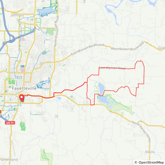
Round Mountain – 24.7 Miles, Moderate, Elevation +1608 FT
From Fayetteville’s Walker Park, this popular clockwise road loop heads east along Wyman Road, featuring rolling blacktop bordered by country estates and the White River valley. Turning south onto Round Mountain Road begins a 3-mile climb to the mountain top. Heading west, riders can expect a twisting descent down to Fayetteville’s Lake Sequoyah and across a picturesque one-lane bridge worth grabbing a photo of.
On your way out or in, consider stopping by the Hip Cafe—a clean and cool coffee café serving a variety of beverages and quick eats throughout the week.
What to know: Riders can expect low traffic density on most routes. Although it features widened shoulders and marked bike lanes, extra caution should be taken along the short section of State Highway 16 leaving and coming back into town. At mile 17.5, riders will encounter another very short section of the highway, only a few hundred yards long. With no mid-ride aid stops, carrying a couple of hydration bottles and a snack should be enough to fuel most riders for this under 25-mile route.
See route details https://ridewithgps.com/routes/32697397
Savoy Loop 50K – 31.2 Miles, Mellow, Elevation +1048 FT
From public parking at the Gary Hampton Softball Complex, this popular local loop heads west on scenic blacktop through unincorporated communities settled following the Civil War. After descending into Wheeler, the road follows tributaries of the Illinois River as pastures span the horizon.
A climb out of the Steele community and a series of large rollers lead to a 2-mile, 300-foot descent into the small community of Savoy. After following the Illinois River south, the route heads east up Goose Creek Road for over 5 miles of county farmlands where old barns dot the landscape. Once back in town (around mile 29), consider stopping off at the Six Twelve Coffee House & Bar for end-of-ride refreshments or find some of our favorite local tacos at La Nueva Luna.
What to know: Depending on the time of day, most roads will have minimum traffic the further west and south you travel. The initial descent on Wheeler Road and north along Barrington can be busy for the 5pm commute. The counterclockwise loop finishes up on North Rupple Road, an urban portion following roads marked as bike routes with a few controlled intersections (stop lights) to navigate. With no mid-ride aid available, make sure you carry the right amount of hydration and nutrition to sustain for the route.
See route details https://ridewithgps.com/routes/32695612

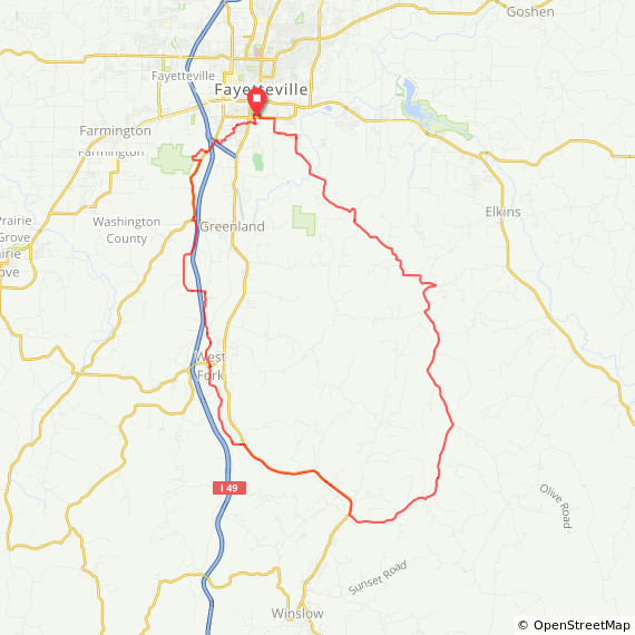
Road to the Whitehouse – 42.9 Miles, Challenging, Elevation +2206
Clockwise from Walker Park, this premier local loop features some of our community’s favorite road riding. Heading southwest from Fayetteville, a brisk climb over Dead Horse Mountain leaves the river valley behind as the route descends along Black Oak Road.
A sharp turn at Sulphur City begins a 500-foot, 7-mile climb up Whitehouse Road for a sample of the Boston Mountains. Picking up a short section of Arkansas Scenic Highway 71, the route crosses the West Fork of the White River as it turns back north towards Fayetteville. The small town of West Fork offers a few unique treats like the Sugar Shack, serving up tasty roadside burgers, tots, and pie. After winding through a few more backroads, the route picks up the NWA Razorback Greenway at Mount Kessler Regional Park and follows the multi-use paved trail back towards Walker Park. If hungry on the ride in, consider a stop at Mr. Taco Loco – a popular trailside taqueria with a bike-friendly patio.
What to know: Although low traffic density can be expected, always follow the rules of the road as this route twists and turns through the Ozark Mountains. While generally lightly traveled, riders should take extra caution on Scenic Highway 71. Upon picking up the Greenway and Fayetteville’s paved trail network, please note the 15mph speed limit and expect to see other users, including dog walkers and joggers.
See route details https://ridewithgps.com/routes/32698530
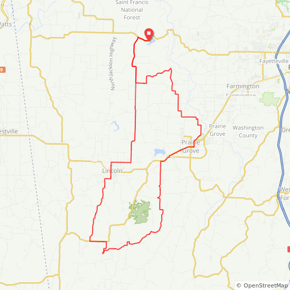
Wedington Blacktop – 52.1 Miles, Moderate, Elevation +2427
Starting from the Lake Wedington Recreation Area just west of Fayetteville, this 50+ mile scenic road route features a mixture of rural county roads and lesser-traveled state highways rolling through Civil War-era communities.
Beginning with a 10-mile stretch of popular pavement on Wedington Blacktop Road, the route heads south across State Highway 62 before dropping through farmlands for a 5-mile descent on Bush Valley Road. Pedaling into the small town of Morrow (mile 21), riders will find a small country store offering daily lunch specials 6 days a week. A series of climbs and descents take riders northeast towards downtown Prairie Grove and through the Prairie Grove Battlefield State Park – a historical battlefield where Union soldiers secured control of Northwest Arkansas in 1862. Following scenic farm roads northwest, the route reconnects with Wedington Blacktop Road for the return ride to Lake Wedington.
What to know: While low traffic density can be expected on much of this route, there is a short half-mile section of riding along State Highway 62 as you make your way into Prairie Grove (mile 32). Most cyclists will feel comfortable with the ample road shoulder available. Prairie Grove offers a variety of aid opportunities like the Magnolia Coffee House – a quaint little place for a mid-ride coffee, latte, or smoothie.
See route details https://ridewithgps.com/routes/32574193
No comments:
Post a Comment